About measuring distance
The Tape measure tool  on the Echogram tools toolbar is used to measure the distance between two or more points (pixels) on an active echogram. This tool provides a quick way to gauge distance on an echogram and could be useful in estimating the size of features like fish schools1, distance between artifacts, a perimeter around a object etc.
On multibeam target echograms the tool can be used to manually measure and store target length.
Distance measurements displayed on single beam echograms and multibeam echograms are described below.
Tape measure distance on single beam echograms
Five distances are calculated and displayed on single beam echograms when the tape measure tool is used: the Length straight-line distance, the Length along-track distance, the GPS straight-line distance, the GPS along-track distance and the Range.
Length straight-line distance
The length straight-line distance (r) between two points, A and B, on a single beam echogram is calculated as:
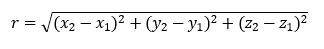
Where:
x1, y1, z1 are geo-referenced coordinates for point A representing latitude, longitude and range
x2, y2, z2 are geo-referenced coordinates for point B representing latitude, longitude and range
Length along-track distance
The length along-track distance (s) on a single beam echogram is the sum of the distances between each ping between points A and B so that:
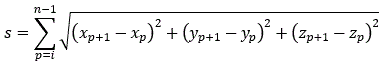
Where:
p is the ping number, i is the ping number of point A and n is the number of pings between A and B (inclusive)
(xp, yp, zp) are geo-referenced coordinates representing latitude, longitude and range for each ping
Notes:
- Latitude and longitude coordinates of each ping are relative to the WGS84 datum.
- Range at a (pixel) point is interpolated from sample ranges.
- zp is linearly interpolated from the ranges at A and B.
GPS straight-line distance
The GPS straight-line distance (r) between two points, A and B, on a single beam echogram is calculated as:
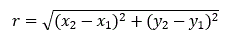
Where:
x1, y1 are geo-referenced coordinates for point A representing latitude and longitude
x2, y2 are geo-referenced coordinates for point B representing latitude and longitude
GPS along-track distance
The GPS along-track distance (s) on a single beam echogram is the sum of the distances between each ping between points A and B so that:
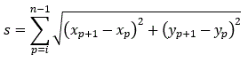
Where:
p is the ping number, i is the ping number of point A and n is the number of pings between A and B (inclusive)
xp, yp are geo-referenced coordinates for point B representing latitude and longitude for each ping
Notes:
- Latitude and longitude coordinates of each ping are relative to the WGS84 datum.
- Range at a (pixel) point is interpolated from sample ranges.
Range
Where:
x is the range of the sample at point 1 or point 2
Tape measure distance on multibeam echograms
The tape measure tool displays a distance measurement between two or more points on the echogram. The shortest distance between each two point segment is calculated with respect to the transducer relative (x,y,z) coordinates of each point.
The example below, shows a detected school on a multibeam echogram with a vertical Tape measure distance across the school.
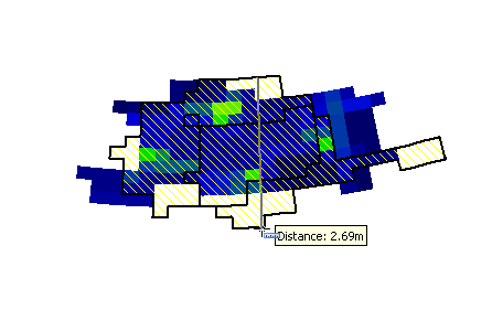
The tape measure straight-line distance r is the distance between A and B and is calculated with the following equation:
Where:
x1, y1, z1 are transducer relative coordinates of point A
x2, y2, z2 are transducer relative coordinates of point B
Limitations
The shortest distance between two points on a multibeam echogram may not necessarily reflect the distance due to the physical conditions.
One example is where multibeam echograms display a conical pattern of beams, as in H-mode pings. The tape measure distance will represent the path through the cone, in most cases. The exception is where two points lie on the same beam; the distance then represents the path along the surface of the cone.
See also
Measuring the distance between two or more points
1The true dimensions of fish schools are given elsewhere in Echoview.