About Echocalc GPS
Overview of Echocalc GPS
Echocalc GPS is a stand-alone utility designed to generate GPS data in Echoview’s text encoded GPS file format. GPS data can be produced based on a number of parameters and initial conditions. The resulting .gps.csv file can be added to an Echoview as a data file; a position variable will be derived from this data file.
Echocalc GPS can be installed by running the Echoview installer, choosing the "Custom" installation option, and selecting Echocalc GPS from the list of utilities. The Echoview installer is available for download from the Echoview website, or on an Echoview USB drive.
Using Echocalc GPS
Creating GPS Data:
-
Open Echocalc GPS from the Windows Start menu.
-
In the CSV file name box, enter a file name for the GPS data file.
-
Specify the parameters, initial conditions and end conditions (see below).
-
Click Make.
Note: A progress bar will be displayed while the program is working and will disappear when the file creation is complete.
Initial and End Conditions
Echocalc GPS creates GPS data based on several initial and end conditions.
|
Setting |
Description |
|
Start date |
Date the first GPS fix |
|
Start time |
Time the first GPS fix |
|
End date |
Date the last GPS fix |
|
End time |
Time the first GPS fix |
|
Start longitude |
Longitude of the first GPS fix |
|
Start latitude |
Latitude of the first GPS fix |
|
Start direction |
Direction taken by the vessel after the first fix (relative to North) |
Parameters
A set of parameters - in combination with the initial and end conditions – determines the form taken by the created GPS data.
|
Setting |
Description |
|
Vessel speed |
Speed of the vessel between the first and last GPS fixes. Note: The vessel speed is assumed to be constant - Echocalc GPS cannot reproduce the effects of varying vessel speed. |
|
Time gap |
Number of seconds between each GPS fix. Note: This affects both the total number of GPS fixes generated and the spatial resolution of the resulting GPS data. |
|
Mode |
Defines the modes of GPS creation (described below). |
|
Transect length |
Length of each transect segment in the initial direction of vessel travel. Note: Available in Transects mode only. |
|
Transect spacing |
Length of each transect segment in the direction orthogonal to the initial direction of travel. Note: Available in Transects mode only. |
GPS creation modes
The three GPS creation modes are:
|
Mode |
Description |
|
Straight Line |
Generates GPS fixes with positions that define a straight line between the positions of the first and last GPS fixes. |
|
Random wander |
Generates GPS fixes initially (for the GPS fix that follows the first) in the direction specified and after that in a direction chosen randomly within +/- five degrees relative to the previous fix. |
|
Transects |
Generates GPS fixes with positions that define a transect pattern based on the parameters Transect length and Transect spacing. The pattern is generated by creating fixes that define a straight line of the length defined by Transect length in the direction specified by Start direction. The direction then changes ninety degrees to starboard, and fixes are created that define a line of the length specified by Transect spacing. The direction then changes ninety degrees to port and fixes are created that define a line of the length specified by Transect length and so on until the GPS fix time reaches or exceeds that of the final GPS fix. |
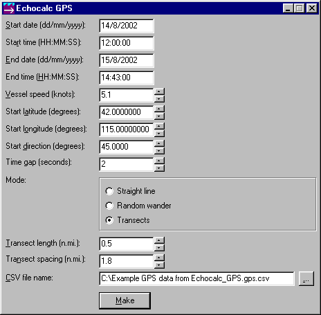
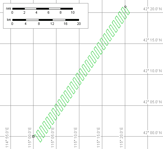
Example
A cruise track created by Echocalc GPS and the initial conditions and parameters that were used to create it are shown below.
|
|
|