Habitat Classification module
The Habitat Classification module allows you to:
- Detect, analyze and classify the bottom substrate from single and split beam data for seabed characterization and habitat mapping purposes, then view and export classification results.
- Detect vegetation boundaries from single and split beam data, then export vegetation analyses.
If you have questions about this module, any of its features or would like to discuss pricing, please contact info@echoview.com.
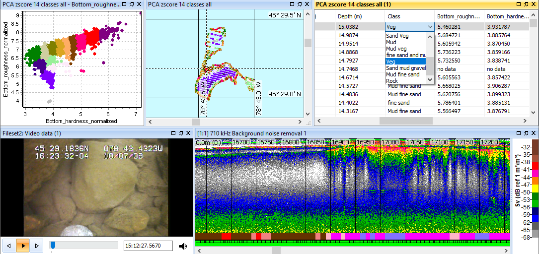
Figure 1. Scott Lake bottom classification with 14 substrate classes. Image shows bottom classification graph, cruise track, results table, video and Sv echogram with bottom classification integram. Thanks to Milne Technologies for the echogram and video data.
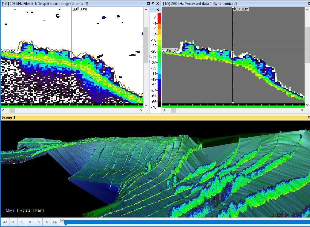
Figure 2. Threshold Offset operator used to detect submerged vegetation (top left), which is then masked (top right) and viewed as a curtain draped over the detected lake floor in a 3D scene (bottom). Threshold Offset lines may be used for Vegetation analysis exports.
Specific features
- Data files and echograms
- Cruise track and maps
- Transects
- Lines and regions
- Operators
- Scenes
- Classify bottom
Data files and echograms
- Unrestricted number of data files that can be loaded at one time.
- Unrestricted viewing of single beam data.
- Seamless viewing over data file boundaries.
- Re-set calibration parameters in post processing.
- No restriction on the resolution of data or number of samples per ping.
- Display data from multiple echosounders and multiple frequencies at the one time.
- Rapid echogram scrolling forwards and backwards.
- Multiple step zooming tools to see data at any level of detail (up to individual samples).
- Rapid adjustment of echogram thresholds.
- View multiple variables (channels) at one time (e.g. TS, phase and detected single targets).
- Instant synchronization of multiple echogram displays.
- Designate "bad data" or "empty water" areas for exclusion from the echo integral.
- Print from echograms, cruise tracks and other windows.
Cruise track and maps
- Display cruise track (from GPS data).
- Quality control of GPS data.
- Display cruise plan using way point list.
- Map/chart display.
- Live viewing of cruise track display during data collection.
- Synchronize echograms to cruise track with single click.
- Display of analysis results (e.g. echo integration) along cruise track.
- Option to import external or quality-controlled GPS data.
- ESRI shape files on the cruise track window.
- Create (along track) regions in the cruise track window.
Transects
- Create and edit transect groups.
- Assign a transect group the platform.
- Define and view transects.
- Import *.transect.csv files.
Lines and regions
- Create and edit lines.
- The Threshold offset line operator may be used to detect the boundary of features like vegetation, transducer ring down, bubbles around the transducer, shadow zones or deadzones.
- The Towed body time offset operator may be used to synchronize an echogram with media recorded from a towed body.
- Create and edit regions.
- Export line data.
Operators
Operators licensed with the Habitat Classification module.
Scenes
- Import surfaces.
- Export scenes in VRML format.
Classify bottom
- Classify Bottom
- Bottom classification data may be viewed as:
- a table with manual Class editing
- a .csv export
- a cruise track
- a Bottom classification integram under a Sv echogram
- a 2D graph with bottom features as axes
- onscreen bottom feature data with results from a Cell integration
Vegetation
Export
- Export data from operators licensed with Habitat Classification.
- Note: In a virtual variable chain, the final variable in the chain is subject to the licensing conditions of any previous operators in the chain.
- Vegetation analysis export.
- Dataflow window, right-click menu export of Variable Properties settings to file.
Notes:
- Auto-synchronization between echogram, bottom classification cruise track and concurrent or geo-located video allows you to synthesize geographic, video and hydroacoustic data information.
See also
About bottom classification
Export file formats
About Echoview modules
Licenses and demonstration mode
Operator licensing in Echoview
About the Threshold offset operator
Detecting a vegetation boundary
Exporting a vegetation analysis